Accelerating the Pre-design Stages with Unparalleled Innovation
Curating the paths…
Cesium Viewer has proved to be one of the most valuable software applications for the construction industry especially benefiting the construction of roads.
With the help of web-based automation, the team at nCircle developed a smart construction dashboard for the development team of a software company offering web-based solutions, CAD customizations, and CAD solutions.
Due to the lack of resourced people in the market for 3D modelling and visualization, the firm partnered with us to work on constructing a smart construction dashboard including a 3D viewer for rendering 3D data and terrains, drawing measurements, and performing cost analysis. Our firm has been working with the client for the last 4 years for 3D visualization. We proposed automated solutions that involved simple designing along with in-depth quantifications saving cost, and time and helping in the growth of the company.
The Backstory
The client collaborated with a Japan-based company to propose development solutions. With their principles revolving around advanced construction techniques, our smart and automated solutions aided in designing, developing, and analysis for road construction. The major objective was to enhance the pre-design stages through the digitization of the process.
5 Reasons for Adopting Smart Construction Dashboard
- Their main objective was to accelerate the pre-construction stages with the help of digital technology.
- With road construction being a challenging task, the end users sought solutions that not only develop the design but also fetch estimations through designing.
- Automated solutions assess the possibilities and offer data associated with the amount of cut and fill required.
- Apart from laying the road path, cross sections can also be developed with this procedure.
- Cut down the hefty process of visiting the site and map the locations to make the entire process error-free up to a large margin.
Challenges
- One of the major challenges when it comes to road construction or development is the estimation of cut and fill costs.
- Another issue that comes up is manually entering the parameters based on the local building codes.
- While generating 3D for the road infrastructure is a task in itself, coming up with 4D and 5D simulations is difficult during the design stage.
- 3D modeling with parameter quantities takes about 10 days to be built in detail which costs not only time but resources as well.
- The client was lacking resourced people to work on the 3D visualization and modeling for this project. With a constant shortage in the industry, we’ve been serving them for the last 4 years.
- Designing roads for big and tough terrains is an extremely difficult task.
Solution
Cesium was one single answer to all the posed challenges. Collaborating with Cesium, we were able to display data extracted from the point clouds which can be taken ahead for creating roads. The advanced technology helped in the following ways:
- We aided in the development of a smart construction dashboard that can be used by designers and architects.
- The adoption of Cesium viewer is one of the solutions that benefit the users through its smart and automated working.
- Whether it’s a simple construction demand or a road for complicated terrains, Cesium viewers can easily derive the costs through advanced technology.
- The web-based automation solution proposed can create roads, and generate cost and material estimation just by entering the parameters.
- The approach generates roads, checks the possibilities and challenges, and also displays the cut and fill amount along with cross sections.
- Point cloud viewer also takes the users to the point cloud of the particular site and offers views.
Working with Cesium Viewer
Cesium is an efficient solution that allows firms to save time and money. The client data is added to the platform which further starts the rendering of the model. A point cloud viewer was added to the Cesium viewer which makes the designing and construction of roads easier at the particular spot.
Quantification and Cost Analysis
Apart from the designing, the challenge of quantification and cost analysis is also catered to through this error-free technique.
Better ROIs
Entering inputs to the platform as per building codes helps in the faster design and offers great ROIs. Faster delivery is also promised as there are preset briefs and parameters as per requirements.
Geo Referencing
Geo-tagged orthographic images can be added to the Cesium viewer and geo-referencing can further be utilized to build roads. It results in cut-fill quantification, material requirements, cost analysis, a cross-section of the rod, and a holistic set of parameters needed for on-site construction.
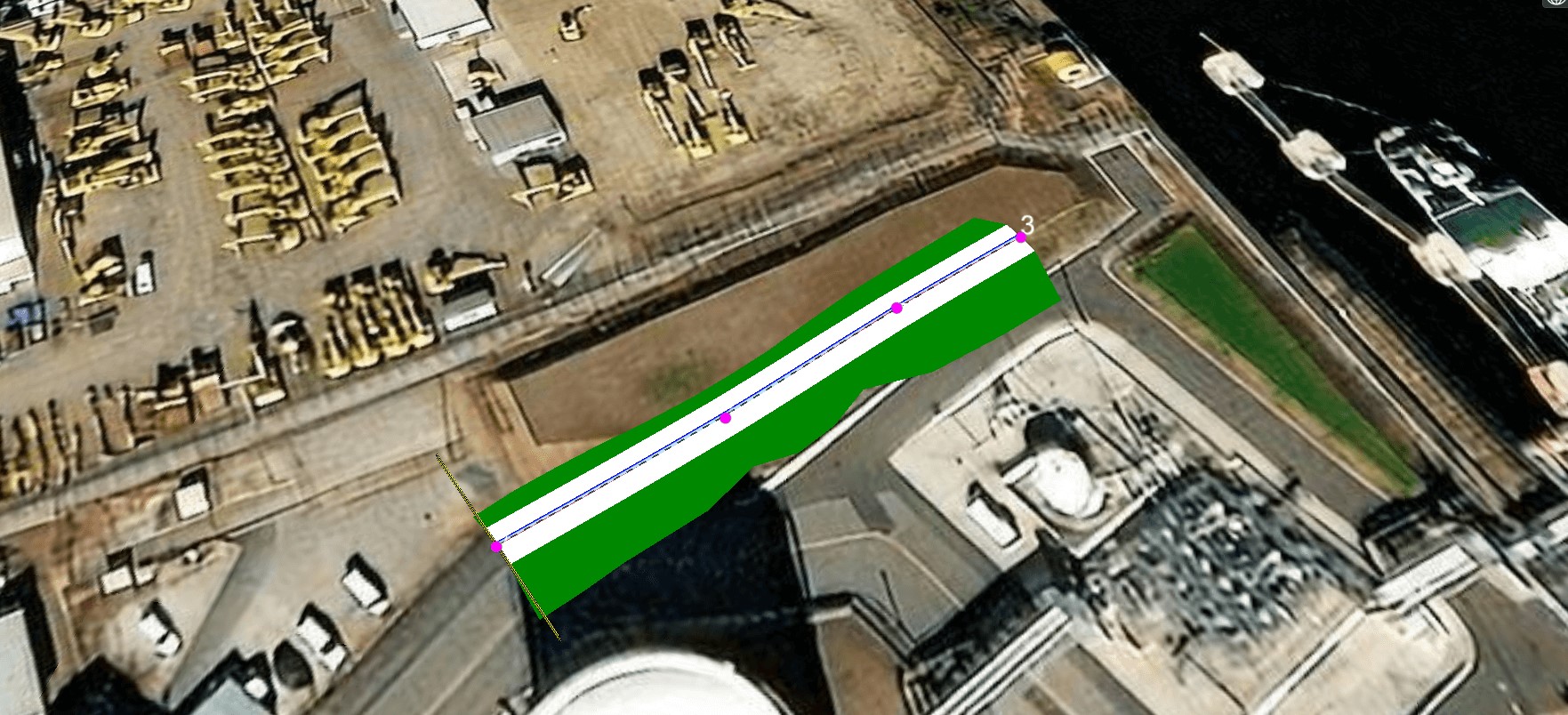
Views and Geometry
The interactive feature generated for this challenge plots the road and displays geometry and views of how the on-site road will look after construction. The process is made even more efficient with color coding, variation in properties, and volumetric calculations.
Better Understanding
Land XML formats are supported to extract the road and view it in a land XML viewer which further helps the client to understand the project and design better.
The Role of nCircle
In the wider picture, the introduction of Cesium can help in a more efficient geospatial process. This approach by nCircle results in the simple addition of data to generate 3D renders. Any project with the scope of the inspection to proceed with construction can benefit from this approach which results in time and cost savings.
Our automated approach has helped in saving time as it cuts down the need for manual modeling or setting up parameters through a hefty process. The proposed solution helped the client to maintain a competitive edge in the industry.